Purpose
 This report describes the methods and results of a pilot study that mapped, evaluated and quantified human-caused disturbances in Land Management Unit (LMU) 9 “Eagle Plains” of the North Yukon Planning Region. It also provides recommendations for how the piloted methods of that study may be applied in other areas of the North Yukon Region and beyond and provides some options and estimated costs to do so.
Abstract
In 2009, the North Yukon Regional Land Use Plan was the first regional plan to be completed and approved as per Chapter 11 of the Umbrella Final Agreement. Many of the recommendations in this Plan were designed to address oil and gas development within the winter range of the Porcupine Caribou herd. A key recommendation was to ensure that the cumulative effects of human activities are kept below levels where impact to caribou over the long term could be expected. More specifically, the Plan recommended that two cumulative effects indicators, surface disturbance and linear disturbance, be quantified and tracked. The Plan went on to say that “recovered” disturbances were to no longer “count” as disturbances.
The Parties to the Plan (Yukon and Vuntut Gwitchin governments) agreed that they should track disturbance levels and that the Yukon Land Use Planning Council (“YLUPC”) check the conformity of project proposals to the plan. To check conformity, YLUPC would (among other things) see if a project would result in excessive disturbances by comparing the combined proposed and existing disturbances to the thresholds specified for that portion of the region (or Land Management Unit (LMU)) (Figure 1). Therefore, measuring existing disturbances are a key part of implementing this plan.
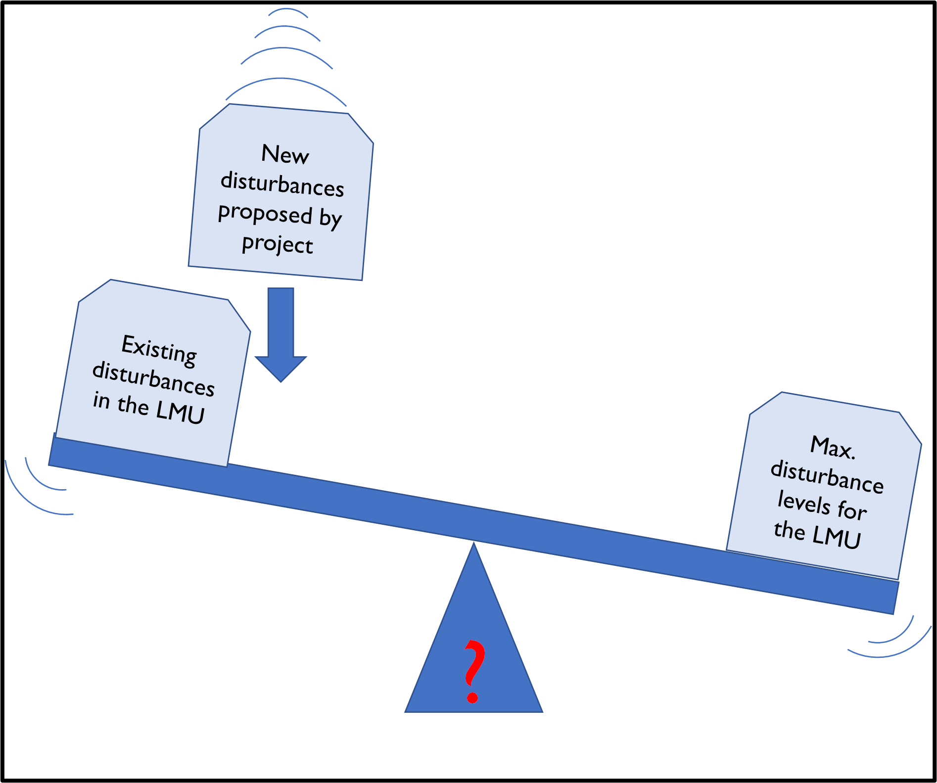
existing disturbances, proposed new disturbances
and the thresholds.
In 2016, YLUPC outlined a pilot study that would determine the amounts of existing disturbances in LMU 9, Eagle Plains, where most of the Region’s human-caused disturbances are found. The piloted method needed to be practical, defensible, and accurate at a regional scale and needed to follow the North Yukon Regional Land Use Plan’s spirit and intent with only minor refinements to the Plan’s definitions of disturbance. The study had the following stages:
1. Determine specifications for imagery – specifically satellite imagery
2. Determine what information needs to be interpreted from the imagery
3. Evaluate field data to support mapping
4. Map and describe disturbances using satellite imagery
5. Analyze maps to calculate disturbance levels
6. Estimate costs for options of rolling out the method beyond the study area
This report describes the methods and results of that pilot study. It developed innovations to standard disturbance mapping procedures to meet the standards set by the Plan and better understand the recovery status of disturbed features. It successfully determined the status of both disturbance indicators in LMU 9. These values are 25% and 51% of the cautionary thresholds for that LMU. However, the cautionary threshold for Linear Density was exceeded before apparent recovery was considered. The methods developed in this pilot study can be used at a regional scale; however, they can be more cost-effective if focused on areas with relatively high disturbance levels.
Key Findings
- A skilled contractor was able to map human-caused (anthropogenic) disturbances using high-resolution satellite imagery.
- The contractor usually was able to: interpret what caused each disturbance, determine an approximate width of linear features, and assign the disturbance one of eight possible vegetation statuses.
- Oblique aerial photos and localized vegetation plot photos and data were used for ground-truthing vegetation interpretation. The oblique aerial photos were the most useful.
- Some vegetation statuses were assumed to meet the North Yukon Regional Plan’s definition of “recovered”. These were disturbances interpreted to have woody regenerating vegetation or where no soil or hydrological modification was evident.
- The mapped disturbances were analyzed to determine the amounts of the two disturbance indicators required in the Plan.
- For LMU 9 “Eagle Plains” the current amount of “Surface Disturbance” and “Linear Density” was determined to be 0.19% and 0.38 km/km2, respectively. These values are 25% and 51% of the cautionary thresholds for that LMU. However, the cautionary threshold for Linear Density was exceeded before apparent recovery was considered.
- The method used in this pilot study was able to determine the current status of both disturbance indicators as required by the Plan. Having been developed, it is the best option if it is urgent to determine the indicator amounts in the remaining LMUs of the Region.
- Several options for determining the disturbance indicators, and their estimated costs, are presented. One that focuses high-resolution imagery and detailed interpretations on LMUs likely to have significant levels of disturbances is recommended. This option was estimated to cost $140k.
- A statistical analysis of vegetation plot data failed to determine recovery rates or clear factors affecting recovery.
- A small number of tasks remain to make the most of this project. Of most importance is to communicate the results and to have them included into assessment processes.